|
 |
View
course map, mile marker, & elevation chart
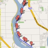
Directions:
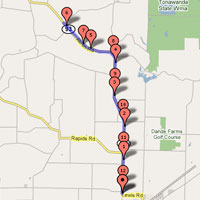
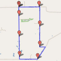
Take state route 5 towards Akron, NY. Turn North on state
route 93. Parking is at Niagara Envelope located at North
end of the village near corner of Hake Rd and Rt. 93. Course
is a flat out and back with 180 degree turn around along state
route 93. |
| |
 |
View
course map, mile marker, & elevation chart
Alabama Course West
View
course map, mile marker, & elevation chart
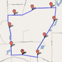
Directions:
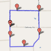
Take Interstate 90 (NYS Thruway) to Town of Pembroke exit
# 48A. Follow state highway 77 North to Phelps Rd. Take a
right turn onto Phelps Rd and follow till road ends at a T
intersection. Turn left and then first right onto Galloway
Rd. Parking for the event is on Gallaway Rd. |
| |
 |
View
course map, mile marker, & elevation chart
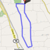
Directions:
From North, take state route 400 until it meets with state
route 16. Follow route 16 south through the town of Chaffee.
Park at Pryme Time Restaurant which is located on left just
past Genesee Rd. On race days we ride from the parking area
to the start line. Distance approximately 2 miles.
From South, take state route 16 north through the intersection
with state route 39. Park at Pryme Time Restaurant located
on right just past Howe Rd but before Genesee Rd. |
| |
 |
View
course map, mile marker, & elevation chart
Directions:
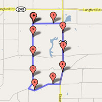
Get to Niagara Falls Boulevard. If you get there via the Youngman
Expressway/Rt. 290, exit at the Niagara Falls Blvd. exit and
head north. You will pass Ellicott Creek Road, Robinson Street,
and then after approx. another mile, cross Tonawanda Creek.
After crossing the bridge over Tonawanda Creek, you will exit
at Connecting Road. That is the actual name of the road and
will take you to Tonawanda Creek Road. (Ponds Unlimited is
at the corner) Turn left onto Tonawanda Creek Road, go past
the marina parking lot and park in the next lot down. |
| |
 |
View
course map, mile marker, & elevation chart
Directions:
coming soon... |
| |
 |
View
course map, mile marker, & elevation chart
Corfu West
View
course map, mile marker, & elevation chart
Directions:
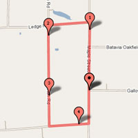
From North: Take Interstate 90 (NYS Thruway) to Town of Pembroke
exit # 48A. Follow state highway 77 South. Follow route 77
through traffic light and into Village of Corfu. Parking is
at middle school located on the right just before traffic
light for state highway 33. On race days we ride from the
parking area to the start line. Distance approximately 5 miles.
From South: Follow state highway 77 into Village of Corfu.
Parking is at middle school located on the left just past
the traffic light fro state highway 33. |
| |
 |
View
course map, mile marker, & elevation chart
Directions:
From the south, take Rt. 90 or Rt. 290 to the Rt 190 north.
Take the Rt. 190 to Grand Island and take the Long Rd. exit
at the north side of the island. Turn left at the exit onto
Grand Island Blvd. and then turn left again onto Long Rd.
Take Long Rd. to where we park at the old Oxy Chemical building
just up the road on the right side.
From the north, take the Rt. 190 south to the Long Rd. exit.
Turn left onto Long Rd. and park at the old Oxy Chemical building
just up the road on the right. |
| |
 |
View
course map, mile marker, & elevation chart
Directions:
Take Rt. 16 south. stay on Rt. 16 south through the towns
of South Wales, Holland, Chaffee, and Yorkshire, and then
into the town of Delevan. In Delevan turn left at the only
traffic signal, onto California Rd. Proceed up the hill to
the end of the road. Turn right onto Bixby Hill Rd. and proceed
down into Elton. Turn left onto county road 21. Parking will
be near the start/finish line near the nursery on the right
side of the road. |
| |
 |
View
course map, mile marker, & elevation chart
Directions:
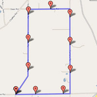
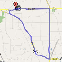
Directions: Take state highway 400 to the US highway 20A exit. Turn left or East on US 20A and follow road to state highway 78. Turn right on state highway 78 and then right again onto Hunters Creek Rd. Parking is in gravel lot for Hunters Creek Park located about a half mile up the hill on the right. On race days we ride from the parking area to the start line. Distance approximately 1 mile.
Hunters Creek Road Race Course Description. Long climbs, Some steep up hill and fast down hill sections. Event usually follows the following route - Hunters Creek Rd, right on Vermont St, right on Vermont Hill Rd, right on Centerline Rd, right on Hunters Creek Rd. One lap equals approximately 14.5 miles.
|
| |
 |
View
course map, mile marker, & elevation chart
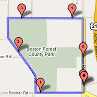
Directions:
Take the Rt 219 and exit at Genesee Road. Turn right and head
east on Genesee Road for approx. 6 miles to Sisson Road /
Rt. 75 and turn right. Head north on Sisson Road for approx.
1.5 miles to Shirley Road and turn left. Take Shirley Road
past Jennings Road and continue on until you come to the highway
department garage on the right-hand side and park. Start/finish
is on Jennings Road just south of Shirley Road. |
| |
 |
View
course map, mile marker, & elevation chart
Marilla Course West
View
course map, mile marker, & elevation chart
Directions:
Parking is at elementary school located on Bullis Rd (Erie
County Route 331) just east of Two Rod Rd in Marilla. From
North, West and South Take state highway 400 to the US highway
20 North exit. Turn right at first traffic light onto Bullis
Rd and take Bullis Rd past Two Rod Rd and park at elementary
school on right. If you are coming from the East (as in Rochester)
take Interstate 90 (NYS Thruway) to Town of Pembroke exit
# 48A. Follow state highway 77 South till US highway 20. Follow
US 20 West through the Village of Alden. Once past the village
turn look for and then left onto Two Rod Rd (Erie County Route
358). Follow Two Rod Rd to Bullis Rd. Turn left and park at
elementary school on right. |
| |
 |
View
course map, mile marker, & elevation chart
Directions:
Take US Highway 219 to the Rice hill road Exit. Turn right
onto to Rice Hill Rd and take first left onto Zimmerman. Take
first left off Zimmerman on to Pfarner (across from fire station)
and park. |
| |
 |
View
course map, mile marker, & elevation chart
Directions:
Take US Highway 400E to the 20A Exit in East Aurora. Take
20A East. Just after woodchuck road at the top of a hill on
the left will be a small company building with parking lot.
Race starts there. |
| |
| |
East
Arcade Road Race Course
Directions From Buffalo Metro: Take state route 400 until it meets with state route 16. Follow route 16 south through the town of Chaffee. Turn left or East on Genesee Rd. Take Genesee Rd about 4 miles to state route 98. Turn left or North on State route 98. Look for East Arcade Rd which will be on the right. Park on closed road located on the right or south side of intersection of state route 98 and East Arcade Rd. On race days we ride from the parking area to the start line. Distance approximately 1 miles.
Directions from North and East: take Interstate 90 (NYS Thruway) to Town of Pembroke exit # 48A. Follow state highway 77 South till merge of state route 98. Follow route 98 into town of Arcade, East Arcade Rd will be on the left. Park on closed road located on the right or south side of intersection of state route 98 and East Arcade Rd. On race days we ride from the parking area to the start line. Distance approximately 1 miles.
Directions from South: Take state route 16 north through the intersection with state route 39. Turn right or East onto Genesee Rd and after about 4 miles turn left or North onto state route 98. Look for East Arcade Rd which will be on the right. Park on closed road located on south side of intersection of state route 98 and East Arcade Rd. On race days we ride from the parking area to the start line. Distance approximately 1 miles.
East Arcade Road Race Course Description. Hilly. Event usually follows the following route. Allen Rd, right on East Arcade Rd, right on Tyler Rd. right on Townline Rd, right on Genesee Rd, right on Allen Rd One lap equals approximately 7.5 miles.
|
| |
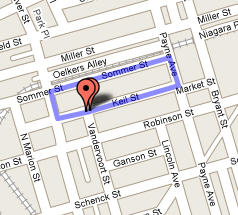 |
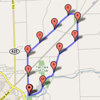
Ascension Criterium
View
course map, mile marker, & elevation chart
From North, South, East and West: Take
New York Thruway (I-90) to Buffalo. Take exit #50 onto
I-290 West towards Niagara Falls. Exit I-290 West at
exit #2 (Colvin Blvd. / State Route 425). Turn right /
North onto Colvin Blvd./ State Route 425 and continue
approximately 2.5 miles to City of North Tonawanda.
Turn left onto Robinson St. and proceed to Ascension
Church at 168 Robinson St. Follow directions to parking.
- From Ontario:
Take QEW to Fort Erie and cross into United States via Peace Bridge.
Take I-190 North to I-290 eastbound. From I-290 East take exit #2
(Colvin Blvd. / State Route 425). Turn left / North onto Colvin
Blvd./ State Route 425 and continue approximately 2.5 miles/4km to
City of North Tonawanda. Turn left onto Robinson St. and
proceed to Ascension Church at 168 Robinson St. Follow directions to
parking.
|
| |
|
|